Francesco Rosselli
Republic of Florence · Renaissance
The story
Florence in the late 15th century had a shop that sold maps, and Francesco Rosselli ran it. It is the first shop known to have dealt in maps as a regular trade, alongside prints and the engraved plates he cut himself.
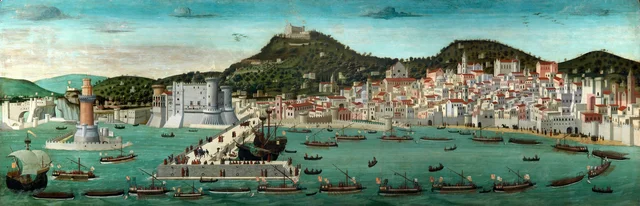
He started as an illuminator, painting miniatures in Florentine manuscripts, among them copies of Ptolemy's Geography, the ancient atlas of the known world, and choir books for the city's cathedral. A painting carries his name too. The long view of Naples known as the Tavola Strozzi, now in the San Martino museum in Naples, is often attributed to him, though scholars have not settled the question.
In the 1480s, deep in debt, Rosselli left Florence, leaving his wife and children with his half-brother, the painter Cosimo Rosselli, and went to Hungary, where he made maps for King Matthias Corvinus. Back home he turned to engraving. His one signed and dated work is a world map of 1506, made with the Venetian cartographer Giovanni Matteo Contarini, the earliest surviving printed map to show the lands Columbus had reached. He was dead by 1513, and only one copy of that map survives, in the British Library in London.